.svg)


Winter road maintenance and snow and ice management demand accurate, up-to-date information about road surface conditions. Traditional road-weather systems (“road weather stations”, RWIS) often rely on direct sensors, complex infrastructure, or pre-defined threshold rules that cannot fully capture the variability of real-world conditions, especially under rapidly changing or site-specific microclimates.
We at Prylada propose an alternative: a sensor-and-machine-learning-based system that combines basic wireless sensors with unsupervised learning to deliver real-time, reliable assessments of road surface state (dry, wet, icy, or hazardous). To enable more effective winter road maintenance and black-ice warnings without requiring expensive or intrusive equipment.
Why conventional RWIS and threshold-based methods are insufficient
Conventional Road Weather Information Systems (RWIS) typically deploy a fixed set of sensors - measuring variables such as air temperature, road surface temperature, humidity, possibly rainfall or wind, and rely on predefined rules or thresholds to infer dangerous states (e.g. when surface temperature drops below zero and humidity is high, risk of ice is rising).
However, this approach has serious limitations:
- Site-specific variability: bridges, viaducts, shaded areas, materials of pavement, local airflow, and microclimates can dramatically change how and when ice forms — thresholds valid for one place may fail in another.
- High cost and limited scalability: full-feature RWIS stations are expensive to install and maintain, especially if you want dense coverage across many road segments.
- Inability to detect subtle or emerging hazards: thin ice, transition states (surface just above freezing, moisture accumulating, partial wetness) may not trigger threshold-based alarms, yet pose serious risks.
Thus, despite decades of development, many hazardous events — especially under complex winter conditions — remain undetected until accidents happen.
The Prylada approach: compact sensors, advanced analytics
Rather than investing in heavy, expensive infrastructure, Prylada uses a network of compact wireless sensors, measuring surface and air temperature, humidity, and radar signal reflections, and combines their data with unsupervised machine learning.
This combination delivers several advantages:
- Cost-effectiveness and scalability: lightweight temperature and humidity sensors, plus radar and connectivity (NB-IoT / LTE), allow deployment even on remote bridges, viaducts, or low-traffic roads.
- Multidimensional insight: rather than relying on single variables, the system evaluates patterns across multiple features (temperature, humidity, radar amplitude, derived radar metrics, humidity–temperature interactions).
- Adaptive hazard detection: the ML model can identify hazardous surface states (ice formation, wet frost, potential black ice) without explicit “ice thickness” sensors.
The principle is supported by academic studies: mmWave radar has emerged as a promising tool for road surface classification in adverse weather, even under snow, ice, and low-visibility conditions.
For example, a recent experimental study reproduced six road surface conditions (dry, wet, thin-ice, ice, snow, sludge) under controlled temperature and humidity, collected mmWave radar data, transformed them via Range-FFT into spectral features, and fed them into machine learning and deep learning models — demonstrating that radar + ML can distinguish complex states with high accuracy.
Another work theoretically showed that low-THz radar frequencies can detect ice layers on roads under a variety of temperature and surface conditions, validating radar-based detection as physically plausible.
Such results confirm the feasibility and scientific basis for combining radar, simple sensors, and ML.
From sensor data to road-surface state: ML process overview
Data collection and feature generation
Each monitoring point collects multiple raw parameters: surface temperature, air temperature, humidity, radar signal amplitude, and additional radar-derived metrics (e.g,. signal decay, backscatter characteristics). Over time — and across weather cycles — this builds a rich multidimensional dataset.
Before training, the data undergoes preprocessing (noise reduction, normalization) and then feature engineering. For instance, Prylada analyzes correlations (e.g., between radar amplitude and ice formation, or humidity vs. temperature), to identify which variables — alone or in combination — reliably signal hazardous conditions.
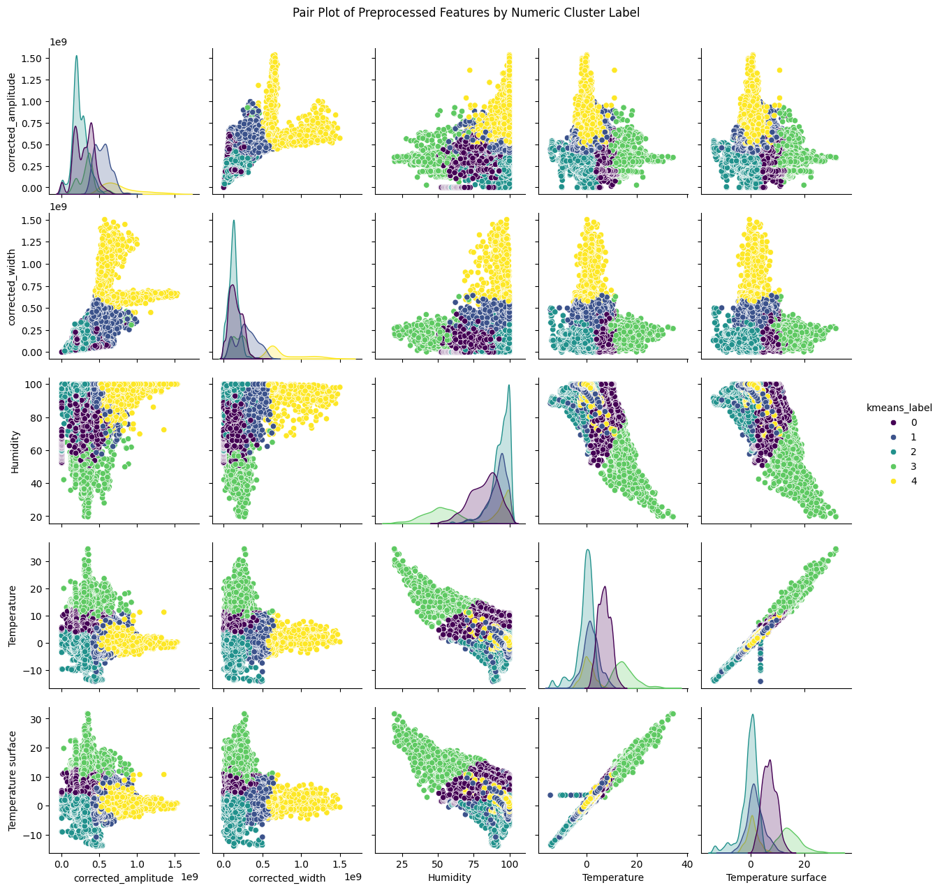
"This is a pair plot of preprocessed features colored by cluster labels. This visualization shows relationships between features such as temperature, humidity, radar amplitude, and derived metrics, highlighting how the model distinguishes different road surface states."


This multi-feature approach is critical: as observed in radar-based studies, complex surface states (ice, thin-ice, wet, snow) often require more than simple mean reflectivity — temporal patterns, spectral features, and multimodal sensor fusion improve classification robustness.
Unsupervised clustering and state discovery
Because it is impractical to label every moment with “ice”, “wet”, “dry”, etc., Prylada uses unsupervised learning (e.g., K-means clustering algorithm) to let the data itself reveal natural groupings of road surface states.
Each data point (a set of sensor readings at a moment in time) is treated as a point in multidimensional “feature space.” The clustering groups similar states — for example, stable dry surface, wet surface, icy/slushy surface, anomaly/noise states — regardless of pre-defined thresholds. Over time, these clusters are analyzed and mapped to meaningful categories (e.g., “safe”, “wet”, “ice risk”, “black ice warning”).
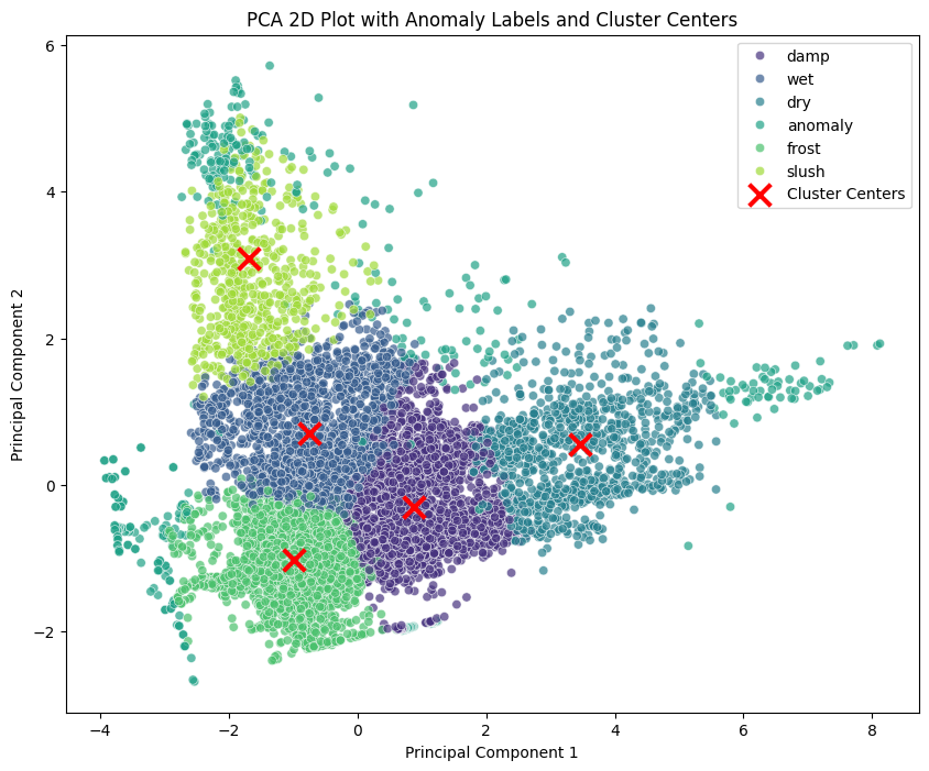
"Here, you see a 2D PCA projection showing cluster centers and labeled anomalies. Each point represents a moment in time with sensor readings projected into two principal components for human comprehension."
This unsupervised clustering approach — as opposed to supervised learning — is particularly suited for road-surface monitoring where labeled datasets are scarce or nonexistent.
Output: clear, actionable road-surface classification
Once clusters are defined and labeled, new sensor readings are classified in real time: for each new measurement vector, the distance to each cluster center is computed, and the nearest cluster determines the road state. This automated classification system delivers:
- road surface condition monitoring
- black ice warning/risk alert
- weather + road condition fusion (surface temperature, humidity, radar, derived features)
Crucially, despite the complexity under the hood, the output remains simple and clear — an indispensable feature for operational use in winter road maintenance and snow-and-ice management services.
Advantages over traditional threshold-based and static sensor-only systems
- Higher sensitivity to complex surface states — by considering multiple features and their interactions, the system can detect subtle transitions (e.g., thin ice forming, mixed wet-ice states) that threshold rules miss.
- Lower cost and easier deployment — wireless sensors + radar allow broad coverage without heavy infrastructure.
- Adaptability to local conditions — the ML model learns patterns specific to each installation (bridge, urban road, forest section), capturing microclimates and site-specific behavior.
- Real-time and continuous monitoring — sensor data is processed as it arrives, enabling timely black ice warnings, safer winter road maintenance decisions, and better planning for snow-and-ice management services.
- Scalability and future extensibility — architecture supports retraining (as new data arrives), adding sensors, refining feature sets, or integrating additional data sources (e.g., weather forecasts, pavement properties).
Positioning within broader RWIS and winter road maintenance practices
While traditional RWIS and road weather stations remain a valid tool for general monitoring, their coverage and cost make them difficult to scale — especially for dense networks covering many roads.
Prylada’s solution does not aim to replace RWIS entirely — rather, it offers a complementary, cost-effective, fine-grained monitoring layer, enabling operators to deploy black ice sensors or radar-based stations selectively on critical segments (bridges, steep slopes, shaded areas, high-risk zones) and cover more ground with better resolution.
In doing so, we enable more efficient snow and ice management services, improved winter road safety, and more informed winter road maintenance — with lower total cost of ownership.
Scientific and practical validation: what research shows
- A recent experimental study using mmWave radar and machine learning demonstrated high accuracy in classifying six road surface conditions (dry, wet, thin-ice, ice, snow, sludge) on asphalt and concrete specimens under a controlled environment.
- Comparative studies show that radar-based road surface classification — when combined with appropriate feature engineering — can achieve recognition rates above 90% for ice-covered surfaces, wet surfaces, and other pavement states.
Together, these results provide robust scientific grounding for Prylada’s approach: the combination of weather sensors, radar, unsupervised machine learning, and real-time classification is not just theoretically sound — but experimentally validated.
Conclusion
In the context of winter road maintenance, snow and ice management, and continuing efforts to improve winter road safety, machine-learning-based road surface condition monitoring offers a powerful complement to traditional RWIS and static sensors.
By leveraging simple wireless sensors, mmWave radar, and unsupervised clustering algorithms (such as K-means), Prylada provides real-time, accurate assessments of road surface states — including detection of hazardous black ice conditions — with a fraction of the cost and infrastructure requirements of classical systems.
This makes it possible to deploy dense networks of smart monitoring points, ensure timely black ice warnings, optimize treatment and maintenance efforts, and ultimately reduce accidents associated with ice formation on roads.
.webp)